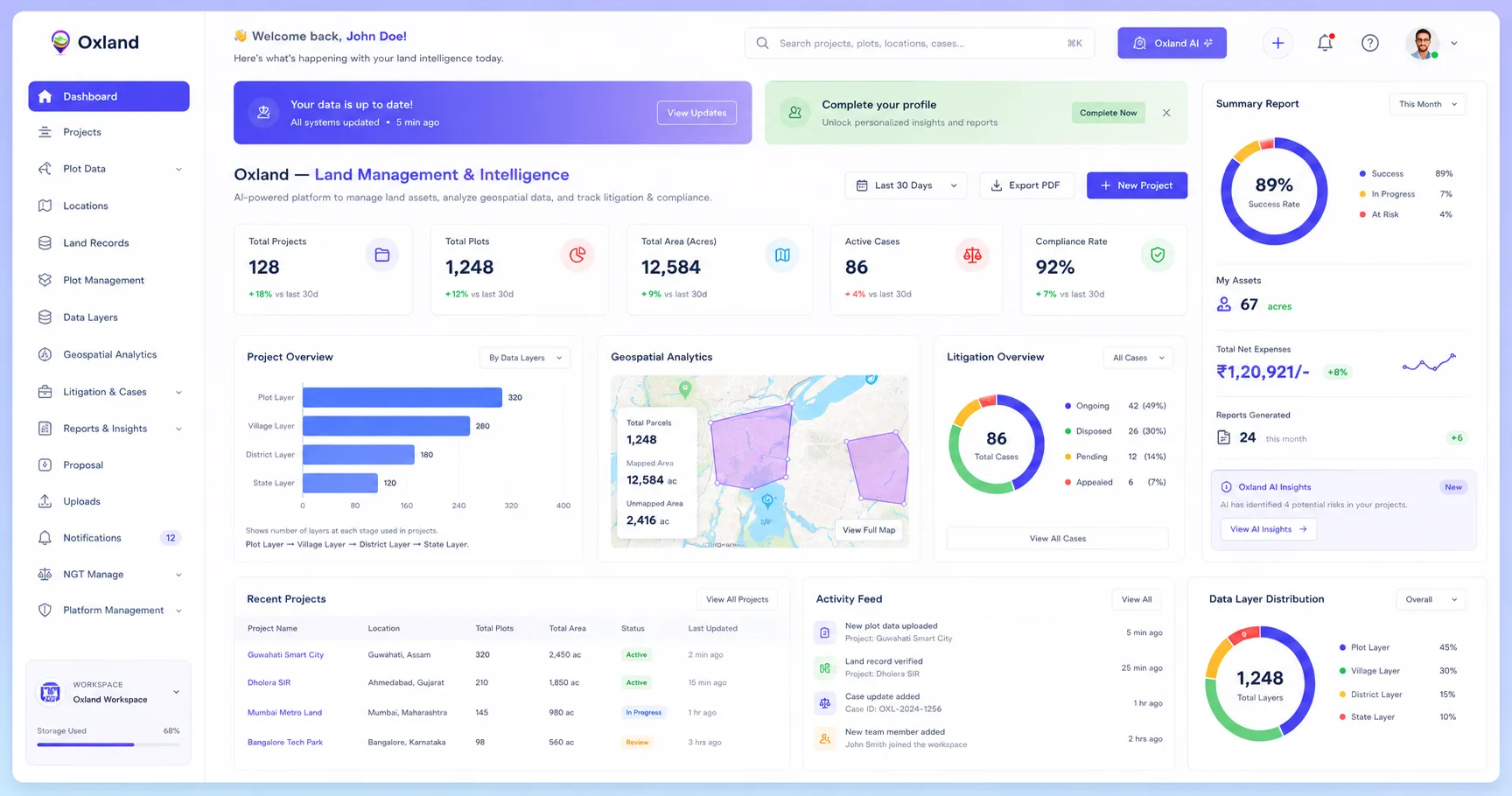
Built for Modern Land Operations

The Operating System for Modern Land Acquisition Teams.

Centralize parcel intelligence, acquisitions, litigation tracking, document workflows, GIS data, approvals, and reporting in a single platform.

    Oxland dashboard

    Trusted by best land teams

    Vedanta
    BALCO
    Eastern Coalfields Limited
    Waaree
    Cairn
    Coal India
    GSL
    SAIL
    Tata
    Moglix
    Athena Power
    JSW
    Tata Steel Foundation
    Aditya Birla Renewables
    Live preview

    See Oxland come to life

    Scroll to open the lid — a real glimpse of the LRMS dashboard your land team will work in every day.

    🔒app.oxland.in/walkthrough

    From raw land data to operational intelligence

    Three steps to a single, connected land operation.

    01

    Import projects & parcels

    Bring in projects, parcels and GIS layers in minutes — spreadsheet, API or map upload.

    02

    Track cases & documents

    Link litigation, proposals and versioned documents directly to the parcels they belong to.

    03

    Manage operations & reporting

    Run acquisitions, approvals and budgets with live dashboards and exportable reports.

    Platform

    Everything your land team needs, in one place

    Say goodbye to scattered spreadsheets and disconnected tools. Oxland unifies acquisitions, parcels, litigation, documents and GIS into one intelligent workspace.

    Land Acquisition
    Parcel Tracking
    Litigation Management
    Proposal Workflow
    GIS Layer Integration
    Document Uploads
    Reporting & Analytics
    Team Collaboration
    Acquisition Intelligence
    Live Jun 2025
    Total Parcels
    350
    +18.6%
    Coverage
    67 ac
    +4.2%
    Budget Used
    ₹1.2M
    82% utilized
    Acquisition Pipeline 350 parcels total
    350 parcels
    Identified
    Active 147
    Under Negotiation
    In Progress 98
    Documentation
    Review 63
    Closed
    Done 42
    Recent Activity
    Parcel KA-441 — owner meeting confirmed
    2m ago
    Litigation #LC-089 — status updated
    1h ago
    Survey report uploaded · Plot 128
    3h ago
    Map-first

    Turn maps into operational intelligence

    Drop a polygon on the cadastre, snap to district boundaries, and Oxland surfaces every parcel inside — KIDE, PNIU, GIS code, ownership — ready for one-click acquisition.

    Parcel overlays Boundaries Acquisition zones Affected areas Layer management
    142
    Parcels
    68ha
    Acquired
    31ha
    Affected
    23.215°N · 77.412°E
    Area of interest
    Selected plot
    Parcel

    Decisions backed by live data

    Acquisition progress, parcel coverage, litigation status and budget — always current.

    Portfolio Growth

    Acquisitions
    Parcels
    406080100JanFebMarAprMayJun
    72%
    Portfolio health
    15
    Projects
    +2%
    120
    Plots
    +5%
    164
    Areas
    +12%
    Pricing

    Simple pricing, built for land teams.

    Start with a free evaluation, or scale to a fully-configured Enterprise deployment.

    14-Day Free Evaluation

    Try OxLand at no cost

    Full access for 14 days.
    Explore OxLand before you commit.

    • Up to 5 Projects / 300 Acres

      Land Management

    • Basic Geospatial Window

    • Land Records

      Module Access

    • Role Based User Access

    • Land Acquisition

      Module Access

    • Basic Reports

    • Cadastral Data

      Management

    • Basic Litigation Management

    • Document Upload & Storage

      Up to 200 MB

    • Interactive Dashboard

    14 days of full access. No credit card required.
    Start 14-Day Free Evaluation
    Built for Enterprises

    OxLand Enterprise

    Unlimited power. Intelligent. Integrated. Enterprise ready.

    Get the complete OxLand experience with unlimited access, advanced intelligence, integrations and dedicated support tailored to your organization's needs.

    • All features in Free version

      With unlimited access & usage

    • Complementary Drone Survey & Mapping*

    • Full Legal & Litigation Management

    • Advanced Geo-AI & OCR Features

    • Advanced Land Records & Cadastral Data Management

    • Advanced MIS & Reporting

    • Important Notifications & Alerts

    • Smart Notifications & Alerts

    • Active Directory Integrations

    • Dedicated Success Manager

    • CRM / ERP Integrations

    • … and many more

    Enterprise pricing is based on project scale, users, integrations and required capabilities.

    Trusted by teams who manage large land operations

    Integrations

    Integrate with the leading tools

    Connect Oxland with the tools you already use.
    Work smarter, automate more, and grow faster.

    SAP
    SAP
    Oracle ERP
    Oracle ERP
    Microsoft Dynamics
    Microsoft Dynamics
    Tally
    Tally
    Zoho Books
    Zoho Books
    Google Maps
    Google Maps

    Seamless
    Integrations

    Connect in minutes
    with no code.

    Secure &
    Reliable

    Enterprise-grade
    security you can trust.

    Automate
    Workflows

    Sync data and save
    hours of manual work.

    Boost
    Productivity

    One platform. All tools.
    Maximum impact.

    Testimonials

    Trusted by India's largest land teams

    From steel and mining to renewables and public infrastructure — see why enterprises run their land operations on Oxland.

    "

    "The GIS capabilities in OxLand are exceptionally well designed. The platform brings together mapping, land records, and operational workflows into a single intuitive system that significantly improves decision-making."

    TS

    Tata Steel

    Head – IT Services

    "

    "OxLand has transformed the way we manage our land bank. Having all land records, legal documents, ownership details, and litigation information in one platform has greatly improved efficiency."

    BA

    BALCO

    Dy. HOD – Legal

    "

    "OxLand has simplified our land management operations by providing complete visibility into land records, acquisition progress, and documentation. It has become an integral part of our workflow."

    VL

    Vedanta Ltd.

    Land Head

    "

    "Managing mining land assets has become significantly easier with OxLand. The GIS-based platform enables better planning, monitoring, and faster access to critical land information."

    VA

    Vedanta Aluminium Metal Ltd.

    CDO – Mines

    "

    "OxLand provides a centralized platform for managing land assets efficiently. The digital workflows and GIS capabilities have improved coordination across our teams."

    ES

    ESL Steel Limited

    Land Head

    "

    "OxLand offers a modern and scalable platform for enterprise land management. The solution is intuitive, highly configurable, and aligns well with large-scale renewable energy projects."

    AB

    Aditya Birla Renewables

    Head – IT
    "

    "The GIS visualization and survey data integration available in OxLand have made monitoring land boundaries and survey information much more efficient and accurate."

    EC

    Eastern Coalfields Ltd. (ECL)

    HOD – Survey

    "

    "OxLand brings together technology, GIS, and workflow automation into a single enterprise platform. It provides the visibility and control required for managing land acquisition at scale."

    WE

    Waaree Energies

    CIO

    "

    "OxLand is a comprehensive digital platform that modernizes land management through automation, centralized records, and intelligent GIS-based insights."

    JC

    JSW Cement

    Digital Head

    "

    "OxLand demonstrates how advanced GIS and AI technologies can solve complex land management challenges. The platform reflects strong technical innovation with practical industry applications."

    IR

    IIT Ropar (iHub AWaDH)

    CEO

    "

    "OxLand effectively combines research-driven innovation with real-world usability. The platform has significant potential for digital land governance and large-scale land management initiatives."

    IT

    IIT Tirupati (IITTNIF)

    Project Director

    "

    "OxLand streamlines land record management, document digitization, and GIS visualization through a single integrated platform, making day-to-day land administration far more efficient."

    SA

    SAIL

    DGM – Land & Estate

    Industries

    Built for every land-intensive operation

    Real Estate

    Developers managing large parcel portfolios.

    Infrastructure

    Right-of-way and corridor acquisition at scale.

    Solar Projects

    Site identification and land aggregation.

    Renewable Energy

    Multi-site land operations and approvals.

    Industrial Development

    Estate planning and plot management.

    Government Projects

    Compliance-ready acquisition workflows.

    Land Consulting

    Litigation, due diligence and advisory.

    Enterprise Teams

    Cross-team collaboration with role control.

    Frequently asked questions

    Everything you need to know to get your land operation running.

    Top Questions

    Most teams are live within a day. Import your existing projects and parcels via spreadsheet or our API, invite your team, and start tracking acquisitions immediately — no lengthy onboarding required.

    Manage land.
    Make better decisions, faster.

    Oxland helps you centralize land data, visualize insights, and streamline your land management workflow — all in one place.

    Centralized Land Data
    Map & Parcel Visualization
    Powerful Insights
    Secure and Reliable